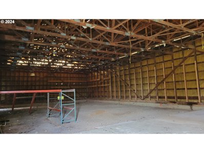
Sherwood OR Commercial for Sale
- Type:
- Business Opportunities
- Sq.Ft.:
- 7,000
- Status:
- Active
- Beds:
- n/a
- Lot size:
- 4.8 Acres
- Year built:
- 1960
- Baths:
- MLS#:
- 24603815
ADDITIONAL INFORMATION
Located on Hwy 99, just south of tualatin and north of Sherwood, this commercial gem is ready for a manufacturing, storage, school or church use. Historically, it and the adjoining land were an onion farm. In fact, nearby Cipole Rd. actuall means "onion" in Italian. The 25,000 plus vehicles that pass daily also make it an ideal location for product sales. The property sits just outside the Tualatin Urban Growth Boundary and is zoned FD-20 with Washington County. This makes entitlement more flexible at this time and poised for a value increase when eventually incorporated into the city of Tualatin. Manufacturing is an allowed use, and when ultimately incorporated, the zoning designation would be MG for General Manufacturing.

Sherwood Real Estate
The median home value in Sherwood, OR is $698,955. This is higher than the county median home value of $545,400. The national median home value is $338,100. The average price of homes sold in Sherwood, OR is $698,955. Approximately 72.3% of Sherwood homes are owned, compared to 25.88% rented, while 1.83% are vacant. Sherwood real estate listings include condos, townhomes, and single family homes for sale. Commercial properties are also available. If you see a property you’re interested in, contact a Sherwood real estate agent to arrange a tour today!
Sherwood, Oregon has a population of 20,281. Sherwood is more family-centric than the surrounding county with 45.24% of the households containing married families with children. The county average for households married with children is 36.2%.
The median household income in Sherwood, Oregon is $104,651. The median household income for the surrounding county is $92,025 compared to the national median of $69,021. The median age of people living in Sherwood is 36.3 years.
Sherwood Weather
The average high temperature in July is 81 degrees, with an average low temperature in January of 35.5 degrees. The average rainfall is approximately 41.6 inches per year, with 0.8 inches of snow per year.
