Port Huron MI Homes for Rent
- Type:
- Land
- Sq.Ft.:
- n/a
- Status:
- Active
- Beds:
- n/a
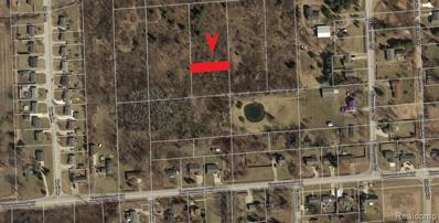
- Lot size:
- 0.13 Acres
- Baths:
- MLS#:
- 40036643
- Subdivision:
- ST CLAIR BOULEVARD SUB
ADDITIONAL INFORMATION
Parcel is North of Ravenswood Road, and between Quain Lane and Minnesota Road. BTVAI.

- Type:
- Land
- Sq.Ft.:
- n/a
- Status:
- Active
- Beds:
- n/a
- Lot size:
- 0.13 Acres
- Baths:
- MLS#:
- 2200020849
- Subdivision:
- ST CLAIR BOULEVARD SUB
View additional info
ADDITIONAL INFORMATION
Parcel is North of Ravenswood Road, and between Quain Lane and Minnesota Road. BTVAI.
$550,000
0 Dove Port Huron, MI 48060
- Type:
- Land
- Sq.Ft.:
- n/a
- Status:
- Active
- Beds:
- n/a
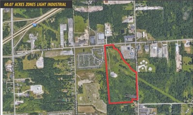
- Lot size:
- 60.07 Acres
- Baths:
- MLS#:
- 31368528
ADDITIONAL INFORMATION
- 60.07 Acres Zoned I-L (Light Industrial) - Utilities Onsite - One Mile to I-94 and Three Miles to I-69 - Seven Miles to Blue Water Bridge and Sarnia Ontario
$550,000
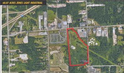
Dove Road Port Huron, MI 48060
- Type:
- Land
- Sq.Ft.:
- n/a
- Status:
- Active
- Beds:
- n/a
- Lot size:
- 60.07 Acres
- Baths:
- MLS#:
- 58031368528
View additional info
ADDITIONAL INFORMATION
- 60.07 Acres Zoned I-L (Light Industrial) - Utilities Onsite - One Mile to I-94 and Three Miles to I-69 - Seven Miles to Blue Water Bridge and Sarnia Ontario
$695,000
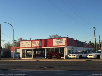
2222 Lapeer Port Huron, MI 48060
- Type:
- Industrial
- Sq.Ft.:
- 10,000
- Status:
- Active
- Beds:
- n/a
- Year built:
- 1999
- Baths:
- MLS#:
- 21402311
ADDITIONAL INFORMATION
Great opportunity to start your own business possibilities are endless. Propert has frontage on lapeer road through to farrend.

Provided through IDX via MiRealSource. Courtesy of MiRealSource Shareholder. Copyright MiRealSource. The information published and disseminated by MiRealSource is communicated verbatim, without change by MiRealSource, as filed with MiRealSource by its members. The accuracy of all information, regardless of source, is not guaranteed or warranted. All information should be independently verified. Copyright 2024 MiRealSource. All rights reserved. The information provided hereby constitutes proprietary information of MiRealSource, Inc. and its shareholders, affiliates and licensees and may not be reproduced or transmitted in any form or by any means, electronic or mechanical, including photocopy, recording, scanning or any information storage and retrieval system, without written permission from MiRealSource, Inc. Provided through IDX via MiRealSource, as the “Source MLS”, courtesy of the Originating MLS shown on the property listing, as the Originating MLS. The information published and disseminated by the Originating MLS is communicated verbatim, without change by the Originating MLS, as filed with it by its members. The accuracy of all information, regardless of source, is not guaranteed or warranted. All information should be independently verified. Copyright 2024 MiRealSource. All rights reserved. The information provided hereby constitutes proprietary information of MiRealSource, Inc. and its shareholders, affiliates and licensees and may not be reproduced or transmitted in any form or by any means, electronic or mechanical, including photocopy, recording, scanning or any information storage and retrieval system, without written permission from MiRealSource, Inc.

The accuracy of all information, regardless of source, is not guaranteed or warranted. All information should be independently verified. This IDX information is from the IDX program of RealComp II Ltd. and is provided exclusively for consumers' personal, non-commercial use and may not be used for any purpose other than to identify prospective properties consumers may be interested in purchasing. IDX provided courtesy of Realcomp II Ltd., via Xome Inc. and Realcomp II Ltd., copyright 2024 Realcomp II Ltd. Shareholders.
Port Huron Real Estate
The median home value in Port Huron, MI is $87,300. This is lower than the county median home value of $149,200. The national median home value is $219,700. The average price of homes sold in Port Huron, MI is $87,300. Approximately 47.72% of Port Huron homes are owned, compared to 42.16% rented, while 10.13% are vacant. Port Huron real estate listings include condos, townhomes, and single family homes for sale. Commercial properties are also available. If you see a property you’re interested in, contact a Port Huron real estate agent to arrange a tour today!
Port Huron, Michigan 48060 has a population of 29,285. Port Huron 48060 is less family-centric than the surrounding county with 23.19% of the households containing married families with children. The county average for households married with children is 28.65%.
The median household income in Port Huron, Michigan 48060 is $36,937. The median household income for the surrounding county is $53,641 compared to the national median of $57,652. The median age of people living in Port Huron 48060 is 36.8 years.
Port Huron Weather
The average high temperature in July is 80.8 degrees, with an average low temperature in January of 18.7 degrees. The average rainfall is approximately 32.8 inches per year, with 37.1 inches of snow per year.